

© 2025 Landeye.com | All Rights Reserved
© 2025 Landeye.com | All Rights Reserved
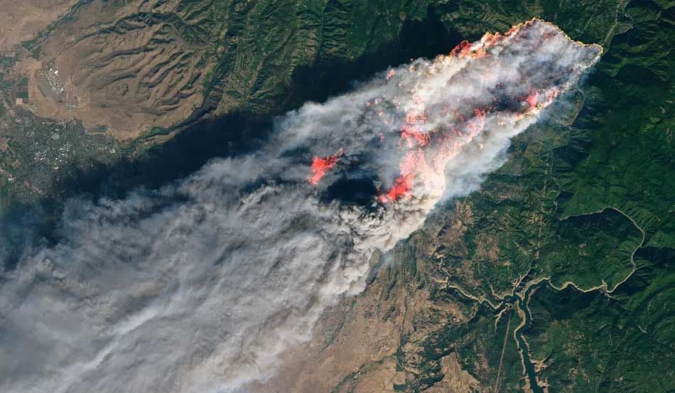
Due to climate change and prolonged drought, wildfires are increasing in frequency and intensity. This increase has put emergency responders, land managers, and public authorities under growing pressure. They must detect fire risks early, track active fires more effectively, and assess damage faster when fires are contained. Satellite imagery can help in multiple stages of wildfire response.
Modern Earth observation systems offer a scalable and data-driven approach to wildfire management that is far more efficient than traditional methods alone. In particular, thermal, hyperspectral, and optical imagery allow decision-makers to identify high-risk vegetation zones before ignition and plan strategic efforts to protect those areas. Furthermore, monitoring active fire fronts in near real time, alongside mapping burn severity and burned areas, enables better support for recovery, restoration, and long-term planning after the disaster.
Responsible teams can use satellite imagery to identify conditions that increase fire susceptibility across large areas. This preventive approach empowers authorities to act early and limit disasters from escalating.
For example, hyperspectral data helps analysts detect vegetation stress and decreasing moisture levels. In addition, thermal bands can highlight abnormal surface heat that often precedes ignition events. This means it’s possible to indicate likely ignition and plan an adequate response.
In other words, combining these signals allows authorities to pinpoint zones with high fuel loads, overheated vegetation, and rapidly changing conditions, driven by drought or irregular heatwaves. That is how decision-makers can plan to prevent disasters by taking measures such as reducing fuel, controlling burns, and preparing access routes early.
Preventive actions reduce risk, but they still fail to eliminate wildfire events in many cases. Satellite imagery is essential during the active event and can help ground teams perform their assigned tasks more efficiently.
Real-time situational awareness, which Earth imagery offers, is vital when a wildfire is underway. These data aid decision-makers in gaining a comprehensive understanding of current fire behavior, which is necessary for predictive modeling and anticipating how conditions may evolve.
Satellite acquisitions support active fire monitoring by enabling:
Satellite imagery continues to play a critical role after fire containment. Typically, organizations and analysts use Earth observation data to accurately assess disaster damage and to serve as the basis for effective recovery planning. At a high level, satellite imagery helps authorities understand how much the land has burned, how severely different areas were affected, and how to prioritize restoration efforts.
Specifically, hyperspectral and multispectral acquisitions support detailed burn severity evaluation. Analysts can leverage high spatial resolution to map burned area extent and classify zones by burn severity levels, ranging from low to high.
In the post-event phase, these analyses support impact assessment across forests, rangelands, agricultural areas, and natural habitats. Data-backed insights set a solid foundation for restoration strategies, insurance claims, and compensation processes. This information remains valuable for ongoing tracking of ecosystem recovery in the long term.
A clear understanding of satellite data types enables informed planning throughout wildfire management. This table outlines key satellite data types and their applications in wildfire response:
| Data Type | Primary Application in Wildfire Management |
|---|---|
| Hyperspectral imagery | Assesses vegetation condition, moisture stress, and enables detailed burn severity analysis using spectral indices |
| Multispectral / optical imagery | Maps fire extent and burn scars, supports visual interpretation of affected areas and perimeter changes |
| Thermal imagery | Detects active fire fronts, hotspots, and residual heat during and after active wildfire events |
| Radar (SAR) | Enables fire and surface monitoring when smoke, clouds, or low light conditions limit optical visibility |
The information provided by Earth imagery benefits all involved teams. Notably:
LandEye is an Earth imagery marketplace, designed to reduce complexity in satellite data access when rapid access and broad coverage are required. The multi-provider approach LandEye offers improves access speed across multiple imagery types.
In this marketplace, users have on-demand access to hyperspectral, multispectral, thermal, and radar imagery from multiple satellite providers, all within a single interface, with fewer procurement barriers. Platform features allow teams to quickly compare coverage, revisit frequency, and pricing across extensive wildfire-prone areas, which reduces delays in data selection during critical periods, such as wildfires.
LandEye supports imagery delivery in formats that analysts can integrate directly into fire-risk assessment, active fire monitoring, and burn-severity modeling pipelines, thereby shortening processing workflows and enabling faster responses.
At the transactional level, this platform streamlines purchasing using transparent escrow-based transactions. This reduces administrative overhead and accelerates access to actionable imagery.
The following representative scenario demonstrates how LandEye supports wildfire response teams.
First, authorities use platform features to define high-risk zones, such as forests, rangelands, and agricultural-forest areas, that require continuous monitoring. Understanding pre-fire conditions is critical for accurate situational assessment. For this reason, LandEye provides access to archival data, alongside recent hyperspectral and thermal imagery.
Analysts use vegetation stress and heat-based indices to detect hotspots with overheated or moisture-deficient vegetation and flag elevated fire risk in surrounding areas. During active fire events, decision-makers can task or purchase newly captured imagery to monitor fire spread and inform operational decisions, thereby supporting tactical responses on the ground.
In addition, acquiring post-event imagery enables comparison of burn severity maps and quantification of impacts, which are needed for recovery planning and long-term monitoring after wildfire containment.
Timely risk assessment, continuous situational awareness, and accurate post-fire analysis across all phases are fundamental to effective wildfire management. Satellite imagery can help response teams by providing wide-area visibility, consistent monitoring, and objective data that support informed decision-making before, during, and after these events.
LandEye’s centralized platform delivers the spatial data teams need through a single interface, reducing friction in data discovery and procurement. This practical approach shortens the path from imagery acquisition to operational insights, improving response speed during critical events.
case studies with similar tags.
Articles with similar tags.
New to LandEye? Visit the Docs to see how tasking, escrow, and provider catalogs work together.