

© 2025 Landeye.com | All Rights Reserved
© 2025 Landeye.com | All Rights Reserved
Precision agriculture replaces traditional farming methods to better manage resources and improve efficiency. This modern approach focuses on optimizing crop management at the field and sub-field levels using data rather than uniform treatment. High-accuracy, up-to-date data contributes to increased yields and effective cost control.
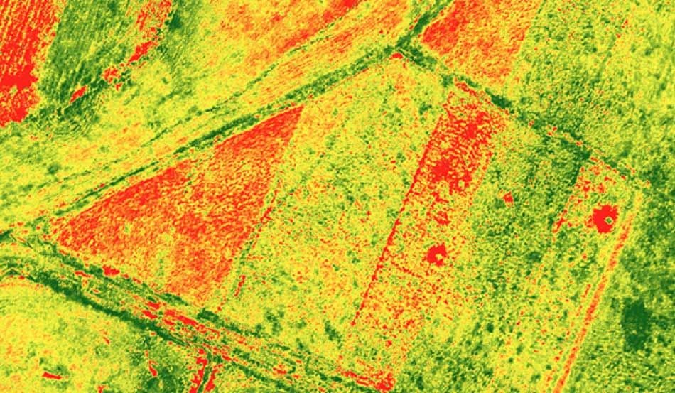
Satellite imagery is a core data source for precision agriculture. Earth observation systems provide consistent, objective visibility into crop conditions, thereby enhancing crop health monitoring. Multispectral and hyperspectral data, in particular, reveal variations in vegetation health, stress, and growth patterns that are not visible from the ground. These insights enable early detection of issues and more informed agronomic decisions.
Traditional agriculture practices face clear limitations. In general, outdated techniques are time-consuming and usually fail to flag emerging issues early.
Farmers treat the entire field similarly, regardless of significant variations in soil conditions, moisture levels, and crop performance. Without wide-coverage satellite acquisitions, landowners are forced to settle for limited ground observations and experience rather than measurable, reliable information.
Under these constraints, determining whether crops are receiving the right amount of water is complex. The same applies to identifying over- or under-irrigated areas. Moreover, nutrient deficiencies may go unnoticed until yield losses become visible. Furthermore, early signs of pests or diseases may remain hidden, and early intervention becomes difficult.
Ultimately, without targeted, accurate data, optimizing the timing and dosage of fertilizer and irrigation becomes seriously challenging. This increases the likelihood of wasted inputs, higher costs, and inconsistent yields.
The following indices play a key role in precision agriculture and crop health monitoring:
This table summarizes useful satellite data types and products for modern precision agriculture workflows:
| Data Type and Product | Operational Purpose | Precision Agriculture Applications |
|---|---|---|
| Multispectral imagery (frequent revisit) | Frequent, consistent crop observation | Operational crop monitoring, vegetation index tracking, growth comparison between fields, early stress detection |
| Hyperspectral imagery | High spectral detail for plant and soil analysis | Detailed crop stress analysis, nutrient deficiency detection, soil–plant interaction assessment, early disease identification |
| DEM and complementary data (weather, soil maps) | Terrain and environmental context | Integrated crop models, irrigation planning, runoff and drainage analysis, yield modeling, field zoning |
Primary beneficiaries of satellite acquisitions in precision agriculture include:
LandEye users have access to multiple types of satellite imagery from various providers. This centralized marketplace ensures that farmers and all relevant teams can access reliable revisit frequency across key agricultural regions throughout the growing season.
With the multi-source approach, LandEye allows users to select the exact imagery they require, based on resolution, frequency, and seasonal needs. If not available at the moment, they can task new acquisitions so a constellation can capture the imagery they need later.
Beyond sourcing imagery, the use of archival imagery enables farm operational teams to establish historical baselines alongside current in-season data, enhancing ongoing crop monitoring. Users receive requested imagery in analysis-ready formats, enabling them to directly integrate datasets into existing modeling systems and support faster decision-making.
In addition, LandEye's transparent, escrow-based payment system is designed to address users' concerns and reduce procurement risks. This means farmers and analysts can rest assured that they only pay for what they actually get. This reduces exposure to fraud.
Operational teams can delineate their areas of interest (AOIs) on the map in LandEye’s dashboard to define fields or agricultural regions. These AOIs serve as the spatial reference for all subsequent data acquisition and analysis.
Following this, users set up periodic imagery acquisitions, for example, on a weekly basis. This approach ensures consistent monitoring throughout the entire growing season. Once configured, relevant vegetation, water stress, or temperature-related indices are computed at each acquisition cycle. The goal is to track crop conditions and detect anomalies.
Datasets are ready for integration into farm management systems or agronomy software upon delivery. These tools use gathered insights to support operational decisions, forecasting, and targeted field interventions.
Satellite imagery is a foundational component of precision agriculture, providing the data needed to implement data-driven farming practices. Consistent, objective information on crop conditions across large agricultural areas enables agribusinesses to detect stress early, analyze field-level variability, and monitor conditions throughout the season. These insights help reduce uncertainty, optimize inputs, and support more accurate yield planning.
LandEye is an end-to-end solution for farmers and analysts who need spatial data, connecting users to multiple providers within a single platform. The analysis-ready data, flexible sourcing, and secure payment system make this centralized marketplace accessible across diverse precision agriculture use cases.
case studies with similar tags.
Articles with similar tags.
New to LandEye? Visit the Docs to see how tasking, escrow, and provider catalogs work together.