

© 2025 Landeye.com | All Rights Reserved
© 2025 Landeye.com | All Rights Reserved
Satellite imagery provides a scalable, objective way to observe changes, helping detect environmental threats early. These risks often unfold across vast areas and in locations where on-the-ground access is difficult. For this reason, spatial data is critical for authorities and responsible organizations to monitor conditions over time and respond more efficiently during disasters.
Furthermore, analysts can use satellite imagery to identify oil spills and water contamination, track deforestation and forest degradation, and assess long-term rangeland and habitat health. This broad-area visibility that these insights deliver supports evidence-based decision-making and consistent environmental oversight.
Oil spills are one of the major threats to marine ecosystems and coastal environments. As a result, regulatory bodies and stakeholders put pressure on responsible officials to detect and initiate rapid response measures.
From a technical standpoint, when a spill occurs from offshore platforms or tankers, it spreads across the sea surface and alters its physical properties, making it detectable by radar sensors. In other words, oil slicks in SAR data create a unique visual signature.
Analysts use SAR imagery to support oil spill response operations by:
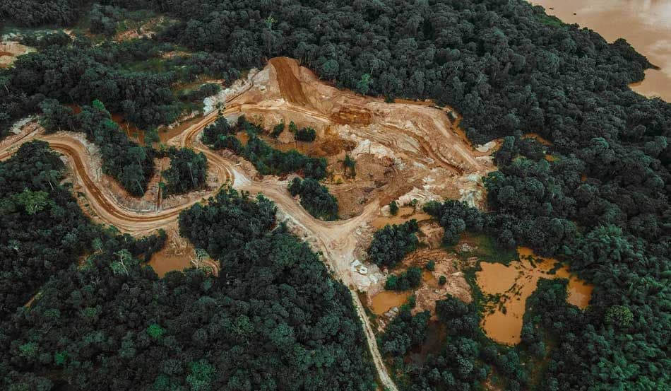
Logging, land-use change, wildfires, and overgrazing are putting ongoing pressure on forests and rangelands. Satellite imagery is useful for continuously monitoring vast areas of these environments, helping identify change patterns that are difficult to observe through ground surveys alone.
Environmental organizations rely on satellite-based monitoring to:
Environmental agencies and authorities typically leverage three types of spatial data for situation monitoring and response, namely:
Organizations use radar signals to identify surface and land-cover changes, regardless of cloud cover or lighting conditions. This enables faster situational awareness, especially in time-sensitive situations.
As noted earlier, SAR data are effective for oil spill detection, as well as for monitoring deforestation or land disturbance in regions with persistent cloud cover.
Optical and multispectral datasets are used for analyzing land cover, monitoring vegetation change, and assessing environmental conditions over large areas. These sensors capture reflected sunlight across multiple spectral bands, which makes them well-suited for these applications.
By recording information across hundreds of narrow spectral bands, hyperspectral imagery enables detailed analysis of vegetation properties and surface materials. This is how responsible authorities accurately classify vegetation and assess environmental conditions at scale.
In practice, organizations responsible for environmental protection rely on satellite data. For example:
LandEye’s centralized platform simplifies access to Earth observation data by delivering satellite imagery from multiple sources in a single interface. For monitoring tasks, LandEye allows teams to select the most appropriate data by combining SAR, optical, and hyperspectral imagery sourced from multiple providers.
The platform supports both routine monitoring and event-driven acquisitions. As a result, this marketplace is well-suited for long-term environmental oversight, as well as for time-sensitive incident response, such as oil spills or illegal land clearing.
The transparent pricing system and escrow-based transactions ensure users pay only for what they actually request and help reduce procurement friction. Another key feature is the delivery of analysis-ready data formats. As a result, teams can directly integrate acquisitions into environmental analytics workflows and reporting models without additional preprocessing.
Satellite imagery improves the efficiency of ecosystem protection and the management of natural resources. Insights provided by observation satellites enable timely detection, continuous environmental monitoring, and objective impact assessment over time.
Authorities and agencies use spatial data to compensate for the limited visibility of ground-based efforts and to gather reliable data to make informed decisions across prevention, monitoring, and response workflows.
Through LandEye, access to both archival and current imagery is straightforward, with minimal complexity in data discovery and purchasing. By linking users to multiple providers, the platform ensures teams can request or acquire the exact datasets needed to manage environmental protection efforts.
case studies with similar tags.
Articles with similar tags.
New to LandEye? Visit the Docs to see how tasking, escrow, and provider catalogs work together.